| Dist. |
Location |
Elevation |
Marking |
Description |
| 0,0 |
Podbanské |
920 m n.m. |
 |
cycle way no. 8 |
| 15,0 |
Štrbské pleso |
1250 m n.m. |
|
cycle way no. 8 |
| 19,5 |
Tatranská Polianka |
1000 m n.m. |
|
cycle way no. 8, crossroad with cycle way no. 9 to Sliezsky dom |
| 28,0 |
Starý Smokovec |
1000 m n.m. |
|
cycle way no. 8, crossroad with cycle way no. 6 to Hrebienok |
| 34,5 |
Tatranská Lomnica |
880 m n.m. |
|
 cycle way no. 8, crossroad with cycle ways no. 3 and 5 cycle way no. 8, crossroad with cycle ways no. 3 and 5 |
| 36,0 |
Tatr. Matliare |
900 m n.m. |
|
cycle way no. 8, crossroad with cycle ways no.8 a 2 |
| 45,0 |
Mlynčeky |
690 m n.m. |
|
cycle way no. 8 |
| 47,5 |
Kežmarok |
640 m n.m. |
|
|
| | museum of Tatry |
|


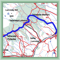 Click to show full-size map
